Empowering climate vulnerable communities in Mongla to develop Locally-Led Adaptation Plans for climate resilience
Address structural inequalities
Devolve decision making
Invest in local capabilities
Collaborative action and investment
Photo credit: Tareq Hasan, BRAC
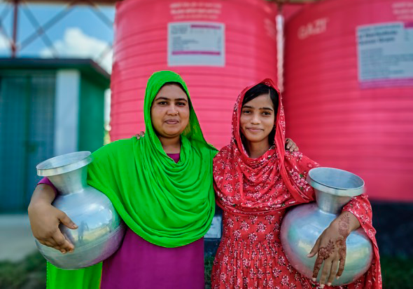
The climate crisis has increased the hardships that young girls like Munira Begum, a resident of Digonto Colony in Bangladesh, are forced to endure.
“We have to walk longer distances to fetch water every day, and have less time to learn, work, and earn”
- Munira Begum, Digonto Colony, Mongla
Digonto Colony is an informal settlement in Mongla, a port city that draws in migrants from the neighboring districts of Barisal, Bagerhat, and Noakhali, particularly in the aftermath of devastating storm surges and cyclones. Life is not much easier in Mongla, however. Migrants must live with informal and unsafe housing, rising levels of salinity that are worsening an already acute drinking water shortage, food insecurity, threats to livelihoods, and added climate-related impacts on mental and physical wellbeing.
Munira and her fellow Digonto residents would not normally have a say in defining priorities for investments by international financial institutions (IFI) in their country. A UK-funded project, implemented under the GCA’s Adaptation Acceleration Program, is now making sure that Munira’s concerns are heard and addressed.
The GCA is working with local partners in Bangladesh to support the residents of informal settlements across several cities to develop People’s Adaptation Plans.
The process for developing these plans is based on best practice by the affiliates of Slum Dwellers International, developed over decades of experience in multiple countries around the world and described in this Guide. Facilitated by local partners and community mobilizers from within the community itself, the process is first and foremost an opportunity for communities to map and understand climate threats. That way, they can negotiate priorities better amongst themselves, with their local and national governments (including through IFIs), and with external fund providers.
The broad methodology focuses on community engagement down to the household level; a recognition of interdependent, multisectoral climate challenges faced by vulnerable communities; genuine partnerships between government, residents, civil society, and academia; and where necessary, a rethinking of conventional approaches and legislation to confront vulnerabilities and resource scarcity.
Planning begins with stakeholder mapping to define roles within communities and build partnerships, along with climate risk assessments conducted by local universities to build institutional capacity. Community members are identified and trained as mobilizers and co-researchers to undertake data collection on behalf of the community, and to map key geographical features and public services on global information systems. Settlement profiling delivers a broad understanding of climate risks and challenges. A process of house-to-house enumeration follows, engaging at the household level. The community then comes together for a climate risk profiling to identify and rank climate risks, and to guide a co-planning process. The result of the co-planning process is a People’s Adaptation Plan, with prioritized and budgeted interventions to guide investments.
“Drinking water was our highest priority,” says Munira. “We therefore prioritized investments in rainwater harvesting systems and the re-excavation of ponds in the colony.”
For the residents of Uporer Char, also in Mongla, the priority was flooding. “Our community is in a low-lying area, so we often deal with flooding,” said Hira Aktar, a resident. “In the absence of drains, even moderate rainfall causes flooding. When it floods, wastewater from toilets mixes with the pond water. In our discussions, we realized that focusing only on drains will not solve the problem. We identified a range of priorities, including toilets built on raised plinths, better drainage infrastructure, and re-excavating canals.”
The planning process is also an opportunity to think outside the box and to develop community systems. In Digonto Colony, for instance, the communities determined that a 50,000-litre water tank is necessary to store enough rainwater for the five months of the dry season. The challenge, however, was the lack of space for a catchment for such a large tank. The community decided to use the local primary school’s roof as the catchment area, and negotiated a written agreement with the school management committee. A water distribution committee of five members was formed to ensure equitable distribution of water.
This committee also has the mandate to collect a small contribution of US$ 1-2 from the households for maintaining the system and has opened a bank account to manage this maintenance fund.
Under the Adaptation Acceleration Program model, the People’s Adaptation Plans are typically linked to investments by IFIs to ensure that the plans can be implemented. But they also become a vehicle for fundraising from other sources. In Mongla, for instance, the residents of climate-vulnerable communities used the plan to negotiate for some of the interventions to be funded from the city’s annual development budget.
“The planning process has opened doors of communication between the municipality and the community. I consider this kind of comprehensive planning the most difficult part of the process. Once that is done, we should be able to implement priority solutions one by one, including as part of the annual development plan.”
- Sheikh Abdur Rahman, former mayor of Mongla.
The UK is also supporting the GCA’s Global Hub on Locally Led Adaptation, which among other things supports knowledge management to inform community adaptation and resilience building efforts, and peer-to-peer learning among communities for problem solving. For instance, community leaders from Mongla shared their experience in developing People’s Adaptation Plans with residents of informal settlements in Kuakata, another secondary city in Bangladesh where the GCA is supporting a People’s Adaptation Plan to inform investments by the Asian Development Bank’s Coastal Towns Climate Resilience Project.